• About
    • About the FIA
    • Priorities
    • Our Team
    • Brainstorming Board
    • Partners and Affiliates
    • Contact Us
  • News + Events
    • News
    • Events
    • Videos
    • Newsletters
    • @FIAumd
    • In the Media
  • Spark Grants
    • Spark Grants Overview
    • Spark Grants FAQ
    • 2012-2015 Seed Grants
    • 2012-2015 Seed Grant Winners
  • Special Topics
    • SearchReSearch
    • Curated Topics
FIA

SearchReSearch

SearchResearch Challenge (8/12/20): Why are some state boundaries so … odd?

Dan Russell • August 12, 2020
 SearchReSearch
Republished with permission from SearchReSearch
SearchResearch Challenge (8/12/20): Why are some state boundaries so … odd? Dan Russell

Why is the US/Canada border so complicated and strange?


There's a lot of discussion about the border between the US and Canada. At the moment, the border is technically closed to US citizens because of COVID, and because of that, there's a certain amount of tension as people from the US try to (and sometimes succeed) at sneaking into Canada.

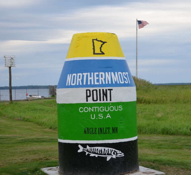
Naturally, that made me curious about the US/Canada border, so I started looking at it, trying to understand how it came to be. And, naturally, one obvious question is "what's the northernmost point of the contiguous United States?" A quick search tells me that it's here, at Angle Inlet, Minnesota.


The border is mostly a long straight line from Vancouver to the middle of Minnesota, and it follows a jagged line when it snakes around islands in the Great Lakes. But then it gets weird in the middle. The borderline takes a sharp left turn due north in the middle of Minnesota, turns left at Angle Inlet, and then meanders back down to to Wheeler's Point and follows the Rainy River, etc etc.


The odd border between Canada and US at Minnesota


That seems pretty weird to me. In general, there are some oddities in states boundaries that demand their backstories. And that's the theme for this week's Challenges: Why are some state boundaries so odd?


1. Why does the US/Canada border take a sudden left turn after passing eastward of Buffalo Point? What's the story there?


2. Similarly, the place where the states of Kentucky, Tennessee, and Missouri meet is also complicated. There's an enclave of Kentucky that's completely surrounded by Missouri and/or Tennessee. How did this little island of Kentucky come to be? (Extra credit: Earthquakes here??)

A small island (enclave) of Kentucky is surrounded by Tennessee and Missouri. Why?


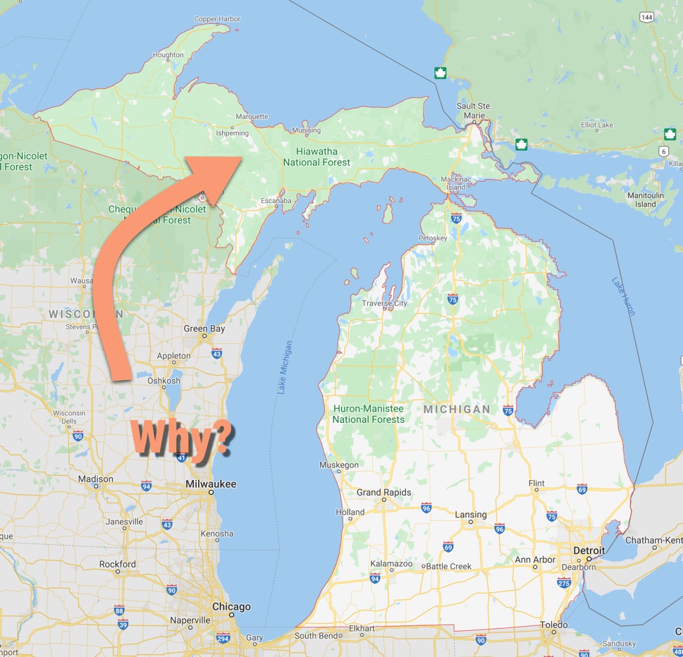
3. The Upper Peninsula of Michigan is another oddity. Any rational drawing of the map would have this part of Michigan be part of Wisconsin. How is it that this peninsula came to be part of Michigan? (Big hint: Toledo turns out to play a part in this story!)


As usual, let us know HOW you find out the answers! I'll be curious to see what you discover.

The Comments are open!


Search on!


Share

Comments

This post was republished. Comments can be viewed and shared via the original site.
11 comments

About the Author

Dan RussellDan Russell

I study the way people search and research. I guess that makes me an anthropologist of search. While I work at Google, my blog and G+ posts reflects my own thoughts and not those of my employer. I am FIA's Future-ist in Residence. More »

Recent News

  • Deepfakes and the Future of Facts
    Deepfakes and the Future of FactsSeptember 27, 2019
  • Book cover for Joy of Search by Daniel M. Russell
    The Joy of Search: A Google Insider’s Guide to Going Beyond the BasicsSeptember 26, 2019
  • The Future of Facts in a ‘Post-Truth’ World
    The Future of Facts in a ‘Post-Truth’ WorldMay 15, 2018
  • The Future of Virtual and Augmented Reality and Immersive Storytelling
    The Future of Virtual and Augmented Reality and Immersive StorytellingJune 6, 2017

More »

Upcoming Events

There are no upcoming events scheduled. Please check back later.
Event Archive »
Video Archive »

Join Email List

SearchReSearch

  • SearchResearch Challenge (3/22/23):  What do you call the sediment that blocks a river from flowing to the sea?
    SearchResearch Challenge (3/22/23): What do you call the sediment that blocks a river from flowing to the sea?March 22, 2023
  • Answer: What do these everyday symbols mean?
    Answer: What do these everyday symbols mean?March 15, 2023
  • SearchResearch Challenge (3/8/23): What do these everyday symbols mean?
    SearchResearch Challenge (3/8/23): What do these everyday symbols mean?March 8, 2023
  • PSA:  Read Clive Thompson’s article about how he does research
    PSA: Read Clive Thompson’s article about how he does researchMarch 3, 2023

More »

University of Maryland logo
Robert W. Deutsch Foundation logo
Google logo
Barrie School
Library of Congress logo
State of Maryland logo
National Archives logo
National Geographic Society logo
National Park Service logo
Newseum logo
Sesame Workshop logo
Smithsonian logo
WAMU
© 2023 The Future of Information Alliance, University of Maryland | Privacy Policy | Web Accessibility