• About
    • About the FIA
    • Priorities
    • Our Team
    • Brainstorming Board
    • Partners and Affiliates
    • Contact Us
  • News + Events
    • News
    • Events
    • Videos
    • Newsletters
    • @FIAumd
    • In the Media
  • Spark Grants
    • Spark Grants Overview
    • Spark Grants FAQ
    • 2012-2015 Seed Grants
    • 2012-2015 Seed Grant Winners
  • Special Topics
    • SearchReSearch
    • Curated Topics
FIA

SearchReSearch

A few wildfire monitoring and satellite image sites (Sept 12, 2020)

Dan Russell • September 12, 2020
 SearchReSearch
Republished with permission from SearchReSearch
A few wildfire monitoring and satellite image sites (Sept 12, 2020) Dan Russell

People keep asking me:


Dan, what's the best site to monitor the fires in California? Or a variation on that: What's the best site to get satellite images of fires in the West?

Without going into all the detail, here's my list of favorite sites, and a brief explanation about what each has that's special.

1. Zoom.earth – excellent near-real-time imagery – they also have a Fire Spots layer that you can turn on/off. They also update their images very frequently. I like to click through hour-by-hour to see a time-lapse of the conditions.
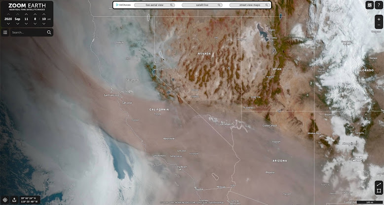

Zoom.earth


2. NASA Worldview daily summary images, with many overlays of data. If you're an advanced satellite image user, this is the place to go to get different spectral views. These can be immensely useful.


NASA Worldview


3. ARCGIS fire mappers With live wind and fire perimeter updates. Coverage: US and Canada.


ARCGIS Firemapper


4. San Diego Supercomputer Center / NSF firemap. Another great map with many (and different!) layers that you can turn on/off. Use the layer selector widget in the upper right corner of the map. (Here I've turned on the fire perimeter map, but if you turn on the "housing density" layer, you can see part of the wildland/urban interface problem.)

SDSC & NSF firemap


5. National Wildfire Coordinating Group Good maps showing final extent of fires using Public NIFS perimeters (which seem to be from ARCGIS). Clicking on a fire shows a LOT of data about the fire: name, acreage, %-contained, fire management group assigned, total personnel on the fire, land ownership, etc.


National Wildfire Coordinating Group fire map


There are more, dozens more, but these are the ones I find my self turning to when I need a quick update. Hope you find them useful.


If you know of any others that should be here, let me know in the comments.


Search on!


Share

Comments

This post was republished. Comments can be viewed and shared via the original site.
1 comment

About the Author

Dan RussellDan Russell

I study the way people search and research. I guess that makes me an anthropologist of search. While I work at Google, my blog and G+ posts reflects my own thoughts and not those of my employer. I am FIA's Future-ist in Residence. More »

Recent News

  • Deepfakes and the Future of Facts
    Deepfakes and the Future of FactsSeptember 27, 2019
  • Book cover for Joy of Search by Daniel M. Russell
    The Joy of Search: A Google Insider’s Guide to Going Beyond the BasicsSeptember 26, 2019
  • The Future of Facts in a ‘Post-Truth’ World
    The Future of Facts in a ‘Post-Truth’ WorldMay 15, 2018
  • The Future of Virtual and Augmented Reality and Immersive Storytelling
    The Future of Virtual and Augmented Reality and Immersive StorytellingJune 6, 2017

More »

Upcoming Events

There are no upcoming events scheduled. Please check back later.
Event Archive »
Video Archive »

Join Email List

SearchReSearch

  • SearchResearch Challenge (3/22/23):  What do you call the sediment that blocks a river from flowing to the sea?
    SearchResearch Challenge (3/22/23): What do you call the sediment that blocks a river from flowing to the sea?March 22, 2023
  • Answer: What do these everyday symbols mean?
    Answer: What do these everyday symbols mean?March 15, 2023
  • SearchResearch Challenge (3/8/23): What do these everyday symbols mean?
    SearchResearch Challenge (3/8/23): What do these everyday symbols mean?March 8, 2023
  • PSA:  Read Clive Thompson’s article about how he does research
    PSA: Read Clive Thompson’s article about how he does researchMarch 3, 2023

More »

University of Maryland logo
Robert W. Deutsch Foundation logo
Google logo
Barrie School
Library of Congress logo
State of Maryland logo
National Archives logo
National Geographic Society logo
National Park Service logo
Newseum logo
Sesame Workshop logo
Smithsonian logo
WAMU
© 2023 The Future of Information Alliance, University of Maryland | Privacy Policy | Web Accessibility